Doris O. Sink "DorisO.Sink"
onale@comteck.comwrites about her ancestors John Arthur
Ritchey
(1838 - 1904) and Rosannah Snowberger (1839 - 1914) who were both born in Snake Spring
Valley, Bedford County, Pa. They were married in Bedford County
in 1862 and moved to White County, Ind. in 1863. John and Rosannah
Ritchey
are Doris's Great Grandparents. John Arthur Ritchey's grandparents
were: Isaac Ritchey (1779 - 1845) & Mary Whetstone / Ritchey (1781
- 1856), who came to Bedford County in about 1800, from Loudoun
County, Virginia. Rosannah Snowberger's grandparents were: Theodore Snowberger (1764 - 1859)
& Elizabeth Eshelman
Snowberger (abt 1776 - 1825) and
Jacob (Snider) Snyder II ( 1753 - 1848) & Catherine Postetter / Snider.
Doris was doing some family
research in the Elgin Illinois, Brethren Library a few years back,
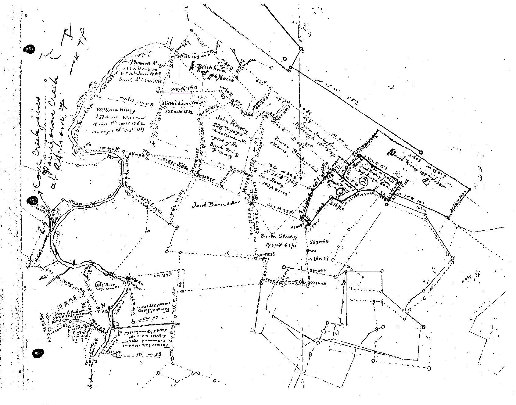
and she found a copy of an old surveyor's map of what turned out
to be the Snake Spring Valley area. She recognized prominent Bedford
County pioneer names and realized at once that it held important
information. She has sent a copy of it for posting on this page!!!
Doris mentioned that the map
showed two tracts of land that were labeled "Brickhouse" tract and "Stonehouse" tract. They were the first things that
I looked for when I received the copy several days later. The
map is located directly below, and oriented such that the hand
writing is generally in an upright position. As you scroll downward,
you will see that the "Brickhouse" tract is one of the first you will see
along the upper-central portion of the map. Just below it, and
a little to the left is the "Stonehouse" tract.
Doris says that her GGG-Grandfather
Jacob Snider / Snyder
II (1753 - 1848) built the "Brickhouse"
in 1811. It was standing "until in the 1970s, a tornado
took the top off of it." Jacob Snider II served in the
Revolutionary War and was one of the early land owners in Snake
Spring Valley (Croyle's Valley), now Snake Spring Twp., Bedford
Co., Pa.
Now start looking at the
names on the other tracts around these. Croyl, Hartley, Stuckey
are the first three to jump off the page - all Bedford County
Pioneer names. Prominent at the top left of the map is Thomas
Croyl.
Thomas (Croyl)
Croyle arrived in Philadelphia,
PA. on the ship "Johnson" from London on September
19, 1732. He spent some the following years in Lancaster County
(now Dauphin County), PA. being listed on 1750 tax list. He came
to what was to become Snake Spring Twp., Bedford County, Penn.
in about 1752. A year later, he started a blacksmith shop in
the area where Bedford County Memorial Hospital is now located.
His home is still standing. (Stonehouse)
Simon Stuckey III (1767 - 1842) arrived in Bedford County
from Virginia in about 1787. His father Simon Stucki II (born in Germany
in about 1719) married Barbara (Fuchs)
Fox in abt 1760. Simon II and Barbara
resided near Hagerstown, Md. Simon Stuckey III married Jacob
Snider / Snyder's sister, Margaret Rose Snyder (1773 - 1833)
in 1793 and had 16 or 17 children.
Another of Doris's relatives,
Jacob Ritchey (1774 - 1850) owned three tracts of land along
the upper edge of the map on the right hand side.
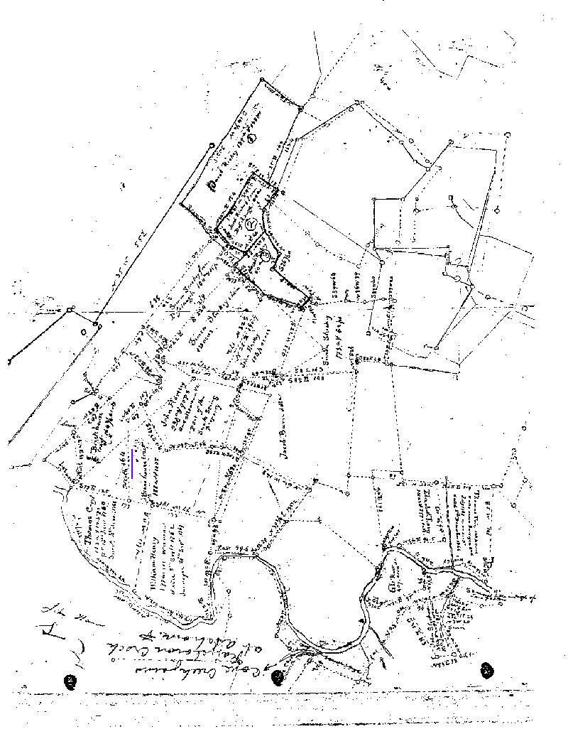
Well, I wanted to experiment
a bit with this map. First, what exactly is this map describing
in present day terms. Second, I was curious to see how accurate
these early surveyors were. To do that, I had to compare it with
a current map of the area. I had hoped to orient this old map
such that the direction north is straight up. There was no north
direction on the map and so that made it a bit more difficult.
Then I noticed that the surveyor dimension directly above the
label "Stonehouse" tract (highlighted with blue line) says"north
164". I assumed that was a compass reading of north and 164
rods in length. Therefore that survey line must be oriented with
magnetic north. Therefore I rotated the map so that survey line
was pointing vertical. (see below)
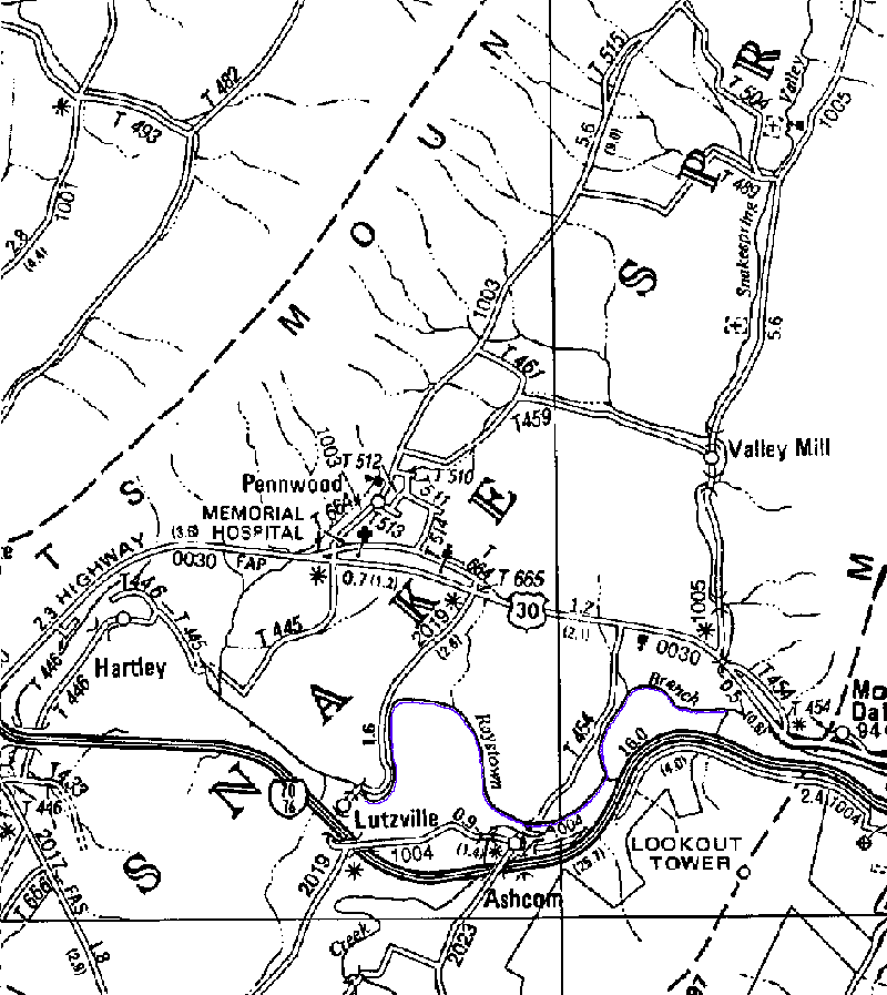
Next
it was necessary to compare the old map with a new map. Since
the "Brickhouse" was in the area of Memorial
Hospital; the Snake Spring Twp. map was chosen and oriented with
north being vertical also. (below)
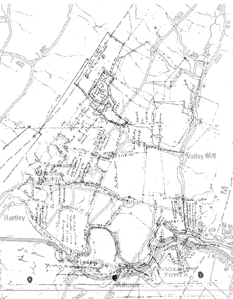
The
last step was to scan both maps with the computer. In doing this,
the area just north of Lutzville and Ashcom contains the Raystown
Branch and its' "S" curve (outlined in blue above) looks
very similar in each of the maps (old and new).
Using
the computer to make the new map transparent so that the two
maps can be placed one over the other, with the old map on the
bottom and the new "transparent" map on top, I used
the computer to change the size of the new map until the "S"
curves of the two maps were the same size. After aligning the
two maps with the "S" curves one over the other, I
could see that other things on the old map lined up very well
with the new map. (I know that the Raystown branch can change
course and shape over a long period of time, however in 150 years
assuming no huge flooding takes place on a regular basis, the
shape should be quite similar.)
(See
below)
The
map above is a composite of the old and new maps. The lighter
gray lines are the "transparent" new map over the top
of the old map. The curves of the Raystown branch lie one over
the other and in the same scale. The small creek that comes into
the Raystown Branch south of Valley Mill (on the new map) lines
up perfectly with the small creek sketched on the old surveyors
map. Old route 30 east of the Memorial Hospital lines up perfectly
with tract boundary lines on the old map. Jacob Ritchey's north- west boundary (on the mountain)
lines up rather well with the ridge on the new map.
Needless
to say, I am impressed with the accuracy of the surveyors map.
I understand when property is resurveyed now, that the boundaries
are generally pretty accurate from one time to the next. But considering
the difference in time and technologies, I am impressed with how
closely these two maps compare.
This
process will be a very useful tool to help locate old family tracts
of land, or old cemeteries, or any old site; onto a new township
map. If two or three common sites can be located on both the old
and new maps, the above technique can be used to locate the position
of the "unknown old" site on the new map, so that it
can be more easily found.
Doris,
thank you so much for sending the map. We're just beginning to
find out a few of the secrets it may hold. I'm sure that it will
produce many thoughts and comments with regard to those individuals
(and their descendants) whose land tracts are shown on the old
map (above). Many of them worked, raised their families and lived
out their days in this area of Bedford County.